A few years ago, I started to get interested in how you might use electronics to improve cave mapping. I participated in a LIDAR survey at Devil’s Sinkhole, which was impressive but the equipment was big, heavy, slow and very expensive. I also saw some small survey equipment cavers were making such as the DistoX and the Shetland Attack Pony, which were also very nice and can speed up a survey by taking shot data, but were not exactly what I was looking for. The time consuming part is sketching, and I wanted to find a way to make it faster and more accurate. Rather than waiting for someone to make the cave survey device I wanted, I realized that I should just do it myself! I am an engineer by profession and had some programming experience as well, plus I got two of my fellow co-workers and cavers involved who had knowledge I did not: Steve Gutting has lots of soldering and electronics assembly experience and Gregg Williams who has extensive machining experience and could help with mechanical design.
My first idea was a basic device that produced LRUDs (left, right, up, and down) measurements continuously along a passage. Since a laser solution seemed too big and costly at the time, I thought ultrasonics might be the way to go. I had worked with some small ultrasonic sensors previously that were relatively inexpensive, so I tried them out in a cave and they seemed to work well. The idea for the first prototype of the Caveatron was to use 4 of these to get the LRUDs and to somehow to figure out the position of the ultrasonic sensors as you move. Getting compass angle and tilt was not too hard since small electronic modules with a magnetometer and accelerometer were not too hard to come by. Distance was another matter. Laser distos (rangefinders) would be the best solution, but they are almost all made with proprietary interfaces and there is no real way to communicate with them (except for some very expensive industrial models). As an alternative, I came up with the idea of using a remote transponder with it's own ultrasonic emitter that sent a pulse to a receiver on the main unit. An infrared LED in the main unit was used to send a signal to activate the transponder’s ultrasonic emitter. The time from sending the IR pulse until receiving the ultrasonic pulse gave a pretty accurate distance measurement (to a centimeter or so) at up to 15 m away.
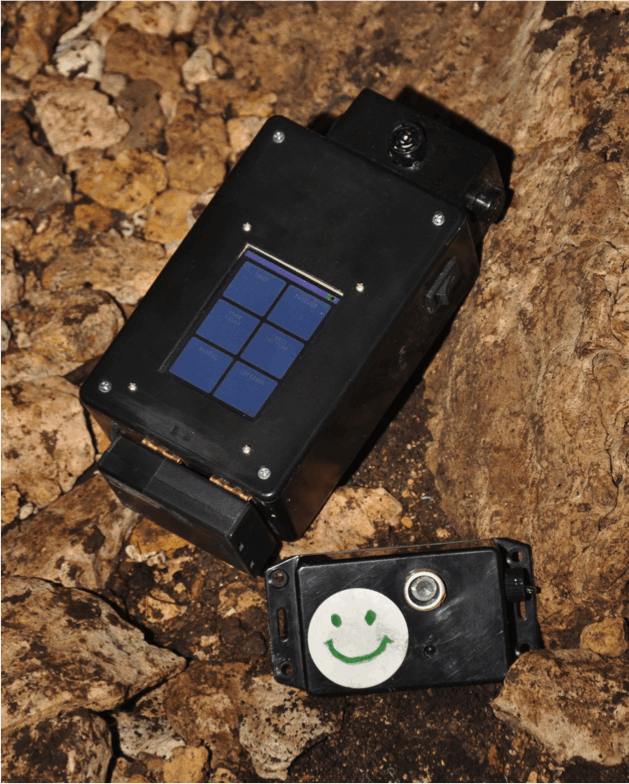
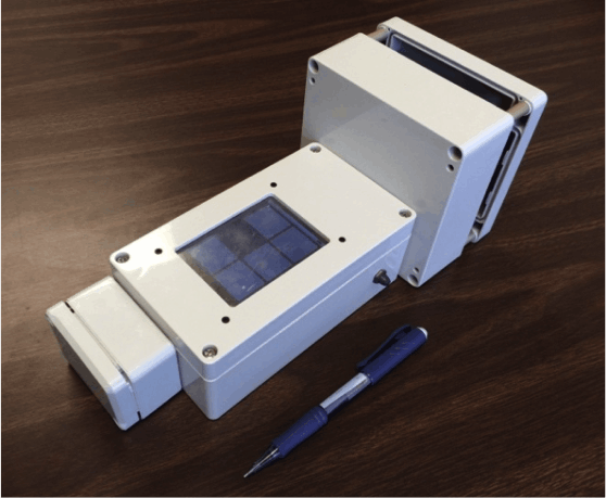
The first prototype had a very basic interface with a numeric membrane keypad and a 2-line text LCD. It stored the LRUD data on a built-in SD card. After a few cave tests, it became obvious that the Caveatron had a lot of potential, including being used to take the regular distance, azimuth and inclination shot data. It also seemed that if it was going to do all these things, a better way of controlling it was needed. I came across some low cost touchscreen displays which would not only allow me to make whatever user interface I needed, but also allow data to be displayed to the user instead of just being stored. So I set out to build the first complete prototype including the display, the LRUD ultrasonic sensors, and added a laser pointer to accurately align it for taking shots and LRUDs. This prototype ran on 4 AA batteries. During testing, it worked well and was it pretty cool to watch it build up the LRUDs as you walked through the cave. However, with further testing some problems became apparent. First the compass calibration was erratic. It would stay relatively good for a time but then suddenly change for no apparently reason (found to be occur when replacing the batteries). Another problem, which became apparent on a longer trip in Deep Cave, was that after a few hours the ultrasonic sensors would start to behave erratically and eventually just quit altogether. After coming out of the cave, they would then go back to normal. I concluded that humidity was the cause, which was a major problem since it would only allow use for short periods in most caves.